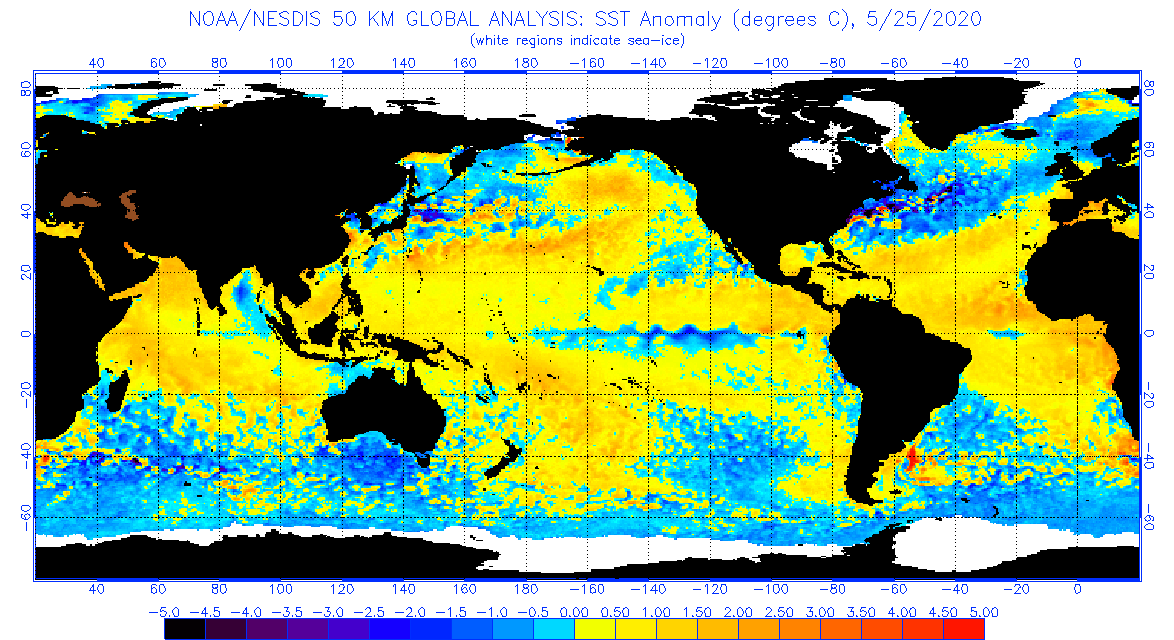
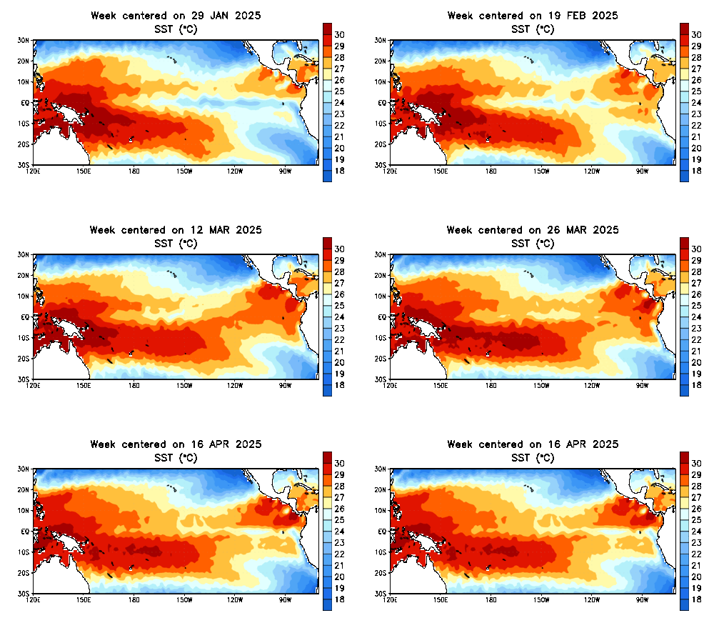
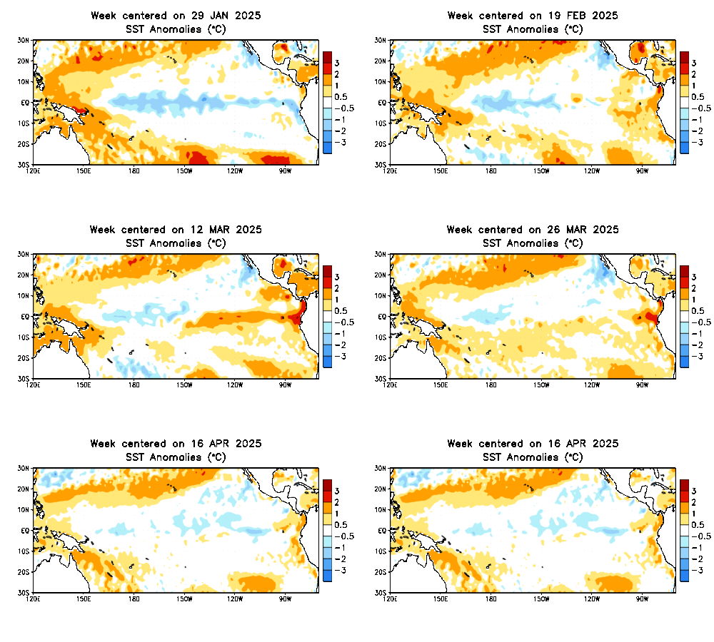
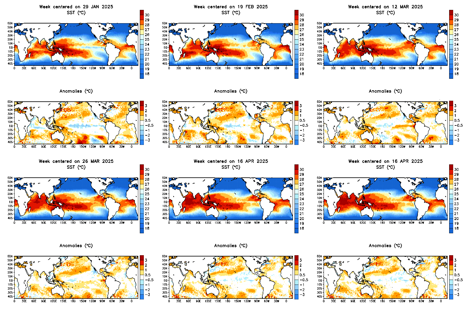
Today, the term El Niño refers to the warming of the ocean surface or above-average sea surface temperatures in the central and eastern tropical Pacific Ocean. This warming causes a shift in the atmospheric circulation with rainfall becoming reduced over Indonesia and Australia, while rainfall and tropical cyclone formation increases over the tropical Pacific Ocean. The low-level surface trade winds either weaken or start blowing from the other direction, i.e. from west to east along the equator.
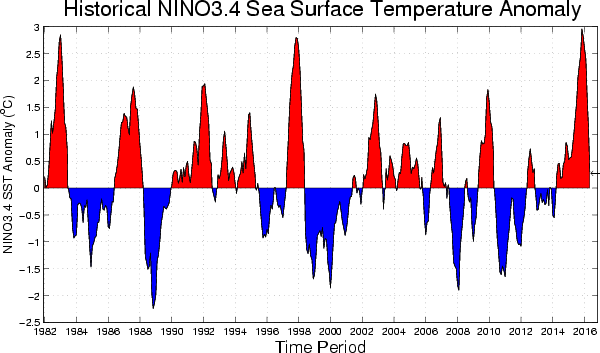
El Niño events are thought to have been occurring for thousands of years. Modern day research techniques have managed to find at least 30 El Niño events since 1900, strongest being ones in 1982-1983, 1997-1998 and 2014-2016. Each country has a different threshold for what is classified as an El Niño event.
There is no consensus on if climate change will have any effect on the occurrance, strength and duration of El Niño events. The anomaly usually happens at irregular intervals of two to seven years, and lasts nine months to two years. Average period length is five years. Every El Niño is different in terms of its magnitude and duration.
El Niño results from interaction between the surface layers of the ocean and the overlying atmosphere in the tropical Pacific. This is a very complicated process and involves unstable air-sea interaction and planetary-scale oceanic waves.
El Niño is detected using several methods, which include in-situ observing systems (buoys) and distance monitoring by satellites. Very complex computer models of the global ocean and atmosphere then use this data to predict El Niño.
- El Niño conditions - warming occurs seven to nine months
- El Niño episode - warming occurs more than nine months
Normal Conditions
- trade winds blow from east to west along the equator, from south america to asia, in the tropical pacific ocean
- sea surface temperature is approximately 8°c (14°f) warmer off the coast of asia than in the eastern pacific
- clouds and rainfall are found in rising air over the warmest water near asia
- east pacific is relatively dry
El Niño Conditions
- trade winds relax in the central and western pacific, i.e. weakening of easterly trade winds
- rainfall follows the warm water eastward, with associated flooding in peru, increased rainfall across the southern tier of the us, drought in indonesia and devastating fires in australia
- large changes in the global atmospheric circulation
Effects of El Niño
- Africa - east africa experiences wetter-than-normal conditions from march to may and drier conditions than normal from december to february in south-central africa
- Asia - extensive drought in the western pacific and rainfall in the normally dry eastern pacific
- Europe - effects are controversial, complex and difficult to analyze
- North America - effects most pronounced from October to March. Majority of Canada has a milder winter and spring (except eastern Canada, where there is no significant impact). In the US, wetter conditions are observed along the Gulf Coast between Texas and Florida, drier conditions are observed in Hawaii, the Ohio Valley, Pacific Northwest and the Rocky Mountains. Wetter weather in California and South-West depends on the strength of that particulat El Niño.
- South America - increased rainfall across the east-central and eastern Pacific Ocean, including parts of South American west coast. Effects are stronger than in the North America and include warm and very wet weather between April and October along the coasts of northern Peru and Ecuador (usually resulting in major flooding). Also, reduction in upwelling of cold, nutrient-rich water leads to fish kills off the shore of Peru and the local fishing industry can suffer severely. Southern Brazil and northern Argentina also experience wetter conditions, usually during the spring and early summer. Central Chile receives a mild winter with lot of rainfall. Drier and hotter weather occurs in parts of the Amazon River Basin, Colombia and Central America.
La Niña conditions are most likely to emerge in November 2024 - January 2025 (59% chance), with a transition to ENSO-neutral most likely by March-May 2025 (61% chance).
Warm (red) and cold (blue) periods based on a threshold of +/- 0.5oC for the Oceanic Niño Index (ONI) [3 month running mean of ERSST.v4 SST anomalies in the Niño 3.4 region (5oN-5oS, 120o-170oW)], based on centered 30-year base periods updated every 5 years.
| Year | DJF | JFM | FMA | MAM | AMJ | MJJ | JJA | JAS | ASO | SON | OND | NDJ |
| 1950 | -1.5 | -1.3 | -1.2 | -1.2 | -1.1 | -0.9 | -0.5 | -0.4 | -0.4 | -0.4 | -0.6 | -0.8 |
| 1951 | -0.8 | -0.5 | -0.2 | 0.2 | 0.4 | 0.6 | 0.7 | 0.9 | 1.0 | 1.2 | 1.0 | 0.8 |
| 1952 | 0.5 | 0.4 | 0.3 | 0.3 | 0.2 | 0.0 | -0.1 | 0.0 | 0.2 | 0.1 | 0.0 | 0.1 |
| 1953 | 0.4 | 0.6 | 0.6 | 0.7 | 0.8 | 0.8 | 0.7 | 0.7 | 0.8 | 0.8 | 0.8 | 0.8 |
| 1954 | 0.8 | 0.5 | 0.0 | -0.4 | -0.5 | -0.5 | -0.6 | -0.8 | -0.9 | -0.8 | -0.7 | -0.7 |
| 1955 | -0.7 | -0.6 | -0.7 | -0.8 | -0.8 | -0.7 | -0.7 | -0.7 | -1.1 | -1.4 | -1.7 | -1.5 |
| 1956 | -1.1 | -0.8 | -0.6 | -0.5 | -0.5 | -0.5 | -0.6 | -0.6 | -0.5 | -0.4 | -0.4 | -0.4 |
| 1957 | -0.2 | 0.1 | 0.4 | 0.7 | 0.9 | 1.1 | 1.3 | 1.3 | 1.3 | 1.4 | 1.5 | 1.7 |
| 1958 | 1.8 | 1.7 | 1.3 | 0.9 | 0.7 | 0.6 | 0.6 | 0.4 | 0.4 | 0.4 | 0.5 | 0.6 |
| 1959 | 0.6 | 0.6 | 0.5 | 0.3 | 0.2 | -0.1 | -0.2 | -0.3 | -0.1 | 0.0 | 0.0 | 0.0 |
| Year | DJF | JFM | FMA | MAM | AMJ | MJJ | JJA | JAS | ASO | SON | OND | NDJ |
| 1960 | -0.1 | -0.1 | -0.1 | 0.0 | 0.0 | 0.0 | 0.1 | 0.2 | 0.3 | 0.2 | 0.1 | 0.1 |
| 1961 | 0.0 | 0.0 | 0.0 | 0.1 | 0.2 | 0.3 | 0.1 | -0.1 | -0.3 | -0.3 | -0.2 | -0.2 |
| 1962 | -0.2 | -0.2 | -0.2 | -0.3 | -0.3 | -0.2 | 0.0 | -0.1 | -0.1 | -0.2 | -0.3 | -0.4 |
| 1963 | -0.4 | -0.2 | 0.2 | 0.3 | 0.3 | 0.5 | 0.9 | 1.1 | 1.2 | 1.3 | 1.4 | 1.3 |
| 1964 | 1.1 | 0.6 | 0.1 | -0.3 | -0.6 | -0.6 | -0.6 | -0.7 | -0.8 | -0.8 | -0.8 | -0.8 |
| 1965 | -0.6 | -0.3 | -0.1 | 0.2 | 0.5 | 0.8 | 1.2 | 1.5 | 1.9 | 2.0 | 2.0 | 1.7 |
| 1966 | 1.4 | 1.2 | 1.0 | 0.7 | 0.4 | 0.2 | 0.2 | 0.1 | -0.1 | -0.1 | -0.2 | -0.3 |
| 1967 | -0.4 | -0.5 | -0.5 | -0.4 | -0.2 | 0.0 | 0.0 | -0.2 | -0.3 | -0.4 | -0.3 | -0.4 |
| 1968 | -0.6 | -0.7 | -0.6 | -0.4 | 0.0 | 0.3 | 0.6 | 0.5 | 0.4 | 0.5 | 0.7 | 1.0 |
| 1969 | 1.1 | 1.1 | 0.9 | 0.8 | 0.6 | 0.4 | 0.4 | 0.5 | 0.8 | 0.9 | 0.8 | 0.6 |
| Year | DJF | JFM | FMA | MAM | AMJ | MJJ | JJA | JAS | ASO | SON | OND | NDJ |
| 1970 | 0.5 | 0.3 | 0.3 | 0.2 | 0.0 | -0.3 | -0.6 | -0.8 | -0.8 | -0.7 | -0.9 | -1.1 |
| 1971 | -1.4 | -1.4 | -1.1 | -0.8 | -0.7 | -0.7 | -0.8 | -0.8 | -0.8 | -0.9 | -1.0 | -0.9 |
| 1972 | -0.7 | -0.4 | 0.1 | 0.4 | 0.7 | 0.9 | 1.1 | 1.4 | 1.6 | 1.8 | 2.1 | 2.1 |
| 1973 | 1.8 | 1.2 | 0.5 | -0.1 | -0.5 | -0.9 | -1.1 | -1.3 | -1.5 | -1.7 | -1.9 | -2.0 |
| 1974 | -1.8 | -1.6 | -1.2 | -1.0 | -0.9 | -0.8 | -0.5 | -0.4 | -0.4 | -0.6 | -0.8 | -0.6 |
| 1975 | -0.5 | -0.6 | -0.7 | -0.7 | -0.8 | -1.0 | -1.1 | -1.2 | -1.4 | -1.4 | -1.6 | -1.7 |
| 1976 | -1.6 | -1.2 | -0.7 | -0.5 | -0.3 | 0.0 | 0.2 | 0.4 | 0.6 | 0.8 | 0.9 | 0.8 |
| 1977 | 0.7 | 0.6 | 0.3 | 0.2 | 0.2 | 0.3 | 0.4 | 0.4 | 0.6 | 0.7 | 0.8 | 0.8 |
| 1978 | 0.7 | 0.4 | 0.1 | -0.2 | -0.3 | -0.3 | -0.4 | -0.4 | -0.4 | -0.3 | -0.1 | 0.0 |
| 1979 | 0.0 | 0.1 | 0.2 | 0.3 | 0.2 | 0.0 | 0.0 | 0.2 | 0.3 | 0.5 | 0.5 | 0.6 |
| Year | DJF | JFM | FMA | MAM | AMJ | MJJ | JJA | JAS | ASO | SON | OND | NDJ |
| 1980 | 0.6 | 0.5 | 0.3 | 0.4 | 0.5 | 0.5 | 0.3 | 0.0 | -0.1 | 0.0 | 0.1 | 0.0 |
| 1981 | -0.3 | -0.5 | -0.5 | -0.4 | -0.3 | -0.3 | -0.3 | -0.2 | -0.2 | -0.1 | -0.2 | -0.1 |
| 1982 | 0.0 | 0.1 | 0.2 | 0.5 | 0.7 | 0.7 | 0.8 | 1.1 | 1.6 | 2.0 | 2.2 | 2.2 |
| 1983 | 2.2 | 1.9 | 1.5 | 1.3 | 1.1 | 0.7 | 0.3 | -0.1 | -0.5 | -0.8 | -1.0 | -0.9 |
| 1984 | -0.6 | -0.4 | -0.3 | -0.4 | -0.5 | -0.4 | -0.3 | -0.2 | -0.2 | -0.6 | -0.9 | -1.1 |
| 1985 | -1.0 | -0.8 | -0.8 | -0.8 | -0.8 | -0.6 | -0.5 | -0.5 | -0.4 | -0.3 | -0.3 | -0.4 |
| 1986 | -0.5 | -0.5 | -0.3 | -0.2 | -0.1 | 0.0 | 0.2 | 0.4 | 0.7 | 0.9 | 1.1 | 1.2 |
| 1987 | 1.2 | 1.2 | 1.1 | 0.9 | 1.0 | 1.2 | 1.5 | 1.7 | 1.6 | 1.5 | 1.3 | 1.1 |
| 1988 | 0.8 | 0.5 | 0.1 | -0.3 | -0.9 | -1.3 | -1.3 | -1.1 | -1.2 | -1.5 | -1.8 | -1.8 |
| 1989 | -1.7 | -1.4 | -1.1 | -0.8 | -0.6 | -0.4 | -0.3 | -0.3 | -0.2 | -0.2 | -0.2 | -0.1 |
| Year | DJF | JFM | FMA | MAM | AMJ | MJJ | JJA | JAS | ASO | SON | OND | NDJ |
| 1990 | 0.1 | 0.2 | 0.3 | 0.3 | 0.3 | 0.3 | 0.3 | 0.4 | 0.4 | 0.3 | 0.4 | 0.4 |
| 1991 | 0.4 | 0.3 | 0.2 | 0.3 | 0.5 | 0.6 | 0.7 | 0.6 | 0.6 | 0.8 | 1.2 | 1.5 |
| 1992 | 1.7 | 1.6 | 1.5 | 1.3 | 1.1 | 0.7 | 0.4 | 0.1 | -0.1 | -0.2 | -0.3 | -0.1 |
| 1993 | 0.1 | 0.3 | 0.5 | 0.7 | 0.7 | 0.6 | 0.3 | 0.3 | 0.2 | 0.1 | 0.0 | 0.1 |
| 1994 | 0.1 | 0.1 | 0.2 | 0.3 | 0.4 | 0.4 | 0.4 | 0.4 | 0.6 | 0.7 | 1.0 | 1.1 |
| 1995 | 1.0 | 0.7 | 0.5 | 0.3 | 0.1 | 0.0 | -0.2 | -0.5 | -0.8 | -1.0 | -1.0 | -1.0 |
| 1996 | -0.9 | -0.8 | -0.6 | -0.4 | -0.3 | -0.3 | -0.3 | -0.3 | -0.4 | -0.4 | -0.4 | -0.5 |
| 1997 | -0.5 | -0.4 | -0.1 | 0.3 | 0.8 | 1.2 | 1.6 | 1.9 | 2.1 | 2.3 | 2.4 | 2.4 |
| 1998 | 2.2 | 1.9 | 1.4 | 1.0 | 0.5 | -0.1 | -0.8 | -1.1 | -1.3 | -1.4 | -1.5 | -1.6 |
| 1999 | -1.5 | -1.3 | -1.1 | -1.0 | -1.0 | -1.0 | -1.1 | -1.1 | -1.2 | -1.3 | -1.5 | -1.7 |
| Year | DJF | JFM | FMA | MAM | AMJ | MJJ | JJA | JAS | ASO | SON | OND | NDJ |
| 2000 | -1.7 | -1.4 | -1.1 | -0.8 | -0.7 | -0.6 | -0.6 | -0.5 | -0.5 | -0.6 | -0.7 | -0.7 |
| 2001 | -0.7 | -0.5 | -0.4 | -0.3 | -0.3 | -0.1 | -0.1 | -0.1 | -0.2 | -0.3 | -0.3 | -0.3 |
| 2002 | -0.1 | 0.0 | 0.1 | 0.2 | 0.4 | 0.7 | 0.8 | 0.9 | 1.0 | 1.2 | 1.3 | 1.1 |
| 2003 | 0.9 | 0.6 | 0.4 | 0.0 | -0.3 | -0.2 | 0.1 | 0.2 | 0.3 | 0.3 | 0.4 | 0.4 |
| 2004 | 0.4 | 0.3 | 0.2 | 0.2 | 0.2 | 0.3 | 0.5 | 0.6 | 0.7 | 0.7 | 0.7 | 0.7 |
| 2005 | 0.6 | 0.6 | 0.4 | 0.4 | 0.3 | 0.1 | -0.1 | -0.1 | -0.1 | -0.3 | -0.6 | -0.8 |
| 2006 | -0.9 | -0.8 | -0.6 | -0.4 | -0.1 | 0.0 | 0.1 | 0.3 | 0.5 | 0.8 | 0.9 | 0.9 |
| 2007 | 0.7 | 0.2 | -0.1 | -0.3 | -0.4 | -0.5 | -0.6 | -0.8 | -1.1 | -1.3 | -1.5 | -1.6 |
| 2008 | -1.6 | -1.5 | -1.3 | -1.0 | -0.8 | -0.6 | -0.4 | -0.2 | -0.2 | -0.4 | -0.6 | -0.7 |
| 2009 | -0.8 | -0.8 | -0.6 | -0.3 | 0.0 | 0.3 | 0.5 | 0.6 | 0.7 | 1.0 | 1.4 | 1.6 |
| Year | DJF | JFM | FMA | MAM | AMJ | MJJ | JJA | JAS | ASO | SON | OND | NDJ |
| 2010 | 1.5 | 1.2 | 0.8 | 0.4 | -0.2 | -0.7 | -1.0 | -1.3 | -1.6 | -1.6 | -1.6 | -1.6 |
| 2011 | -1.4 | -1.2 | -0.9 | -0.7 | -0.6 | -0.4 | -0.5 | -0.6 | -0.8 | -1.0 | -1.1 | -1.0 |
| 2012 | -0.9 | -0.7 | -0.6 | -0.5 | -0.3 | 0.0 | 0.2 | 0.4 | 0.4 | 0.3 | 0.1 | -0.2 |
| 2013 | -0.4 | -0.4 | -0.3 | -0.3 | -0.4 | -0.4 | -0.4 | -0.3 | -0.3 | -0.2 | -0.2 | -0.3 |
| 2014 | -0.4 | -0.5 | -0.3 | 0.0 | 0.2 | 0.2 | 0.0 | 0.1 | 0.2 | 0.5 | 0.6 | 0.7 |
| 2015 | 0.5 | 0.5 | 0.5 | 0.7 | 0.9 | 1.2 | 1.5 | 1.9 | 2.2 | 2.4 | 2.6 | 2.6 |
| 2016 | 2.5 | 2.1 | 1.6 | 0.9 | 0.4 | -0.1 | -0.4 | -0.5 | -0.6 | -0.7 | -0.7 | -0.6 |
| 2017 | -0.3 | -0.2 | 0.1 | 0.2 | 0.3 | 0.3 | 0.1 | -0.1 | -0.4 | -0.7 | -0.8 | -1.0 |
| 2018 | -0.9 | -0.9 | -0.7 | -0.5 | -0.2 | 0.0 | 0.1 | 0.2 | 0.5 | 0.8 | 0.9 | 0.8 |
| 2019 | 0.7 | 0.7 | 0.7 | 0.7 | 0.5 | 0.5 | 0.3 | 0.1 | 0.2 | 0.3 | 0.5 | 0.5 |
| Year | DJF | JFM | FMA | MAM | AMJ | MJJ | JJA | JAS | ASO | SON | OND | NDJ |
| 2020 | 0.5 | 0.5 | 0.4 | 0.2 | -0.1 | -0.3 | -0.4 | -0.6 | -0.9 | -1.2 | -1.3 | -1.2 |
| 2021 | -1.0 | -0.9 | -0.8 | -0.7 | -0.5 | -0.4 | -0.4 | -0.5 | -0.7 | -0.8 | -1.0 | -1.0 |
| 2022 | -1.0 | -0.9 | -1.0 | -1.1 | -1.0 | -0.9 | -0.8 | -0.9 | -1.0 | -1.0 | -0.9 | -0.8 |
| 2023 | -0.7 | -0.4 | -0.1 | 0.2 | 0.5 | 0.8 | 1.1 | 1.3 | 1.6 | 1.8 | 1.9 | 2.0 |
| 2024 | 1.8 | 1.5 | 1.1 | 0.7 | 0.4 | 0.2 | 0.0 | -0.1 | -0.2 | -0.2 |


